

Strong thunderstorms for NJ Wednesday – 40 mph Dorian gusts late-week
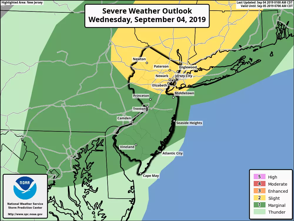
SEVERE THUNDERSTORM WATCH until 9 p.m. for Bergen, Essex, Hudson, Hunterdon, Mercer, Middlesex, Monmouth, Morris, Passaic, Somersetm Sussex, Union and Warren counties
I'll give you the latest Dorian update in a sec. But first, we have a cold front to talk about for Wednesday. This leading edge of cooler, drier air will actually have three effects for the Garden State:
1.) It will drive through a round of scattered showers and thunderstorms starting Wednesday mid-afternoon.
2.) It will kickstart a cooldown over the next couple of days.
3.) It will help steer Hurricane Dorian out to sea.
We're starting off this Wednesday morning with lots of 60s on the temperature map. It's going to be a very warm, humid, and breezy day with highs reaching the mid to upper 80s. I wouldn't be surprised if someone in interior NJ hits the 90-degree mark Wednesday afternoon.
I've actually brightened up the forecast quite a bit, with some good sunshine for the first half of the day. But our approaching cold front will begin sparking thunderstorms in northwestern New Jersey around 3 p.m. (give or take). I'm thinking that line of showers and storms will make it to the Jersey Shore (Monmouth/Ocean counties) around 6 p.m. and South Jersey (Atlantic/Cape May counties) closer to 9 p.m.
Storm cells may become strong or severe, especially in the warmth and humidity of the afternoon. Pockets of heavy rain, marginally gusty winds, small hail, and even an isolated tornado are possible. Given the timing, North Jersey will be under the gun for the strongest storms.
As rain activity exits late Wednesday evening (around Midnight), it will feel more comfortable as humidity drops away a bit. Overnight low temperatures will dip into the mid 60s.
Usually after a cold front passage, our skies clear out and we get to enjoy some pleasant, refreshing weather. But Dorian has other plans!
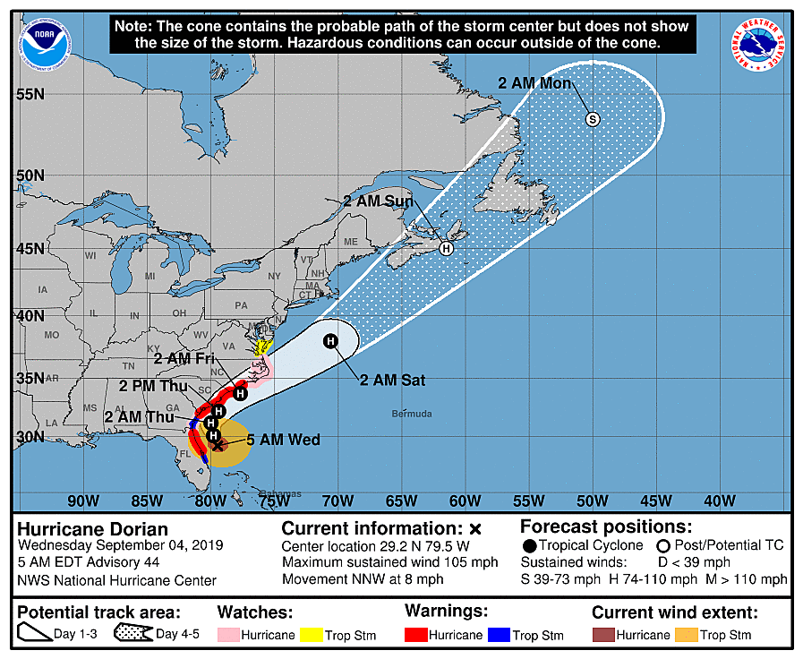
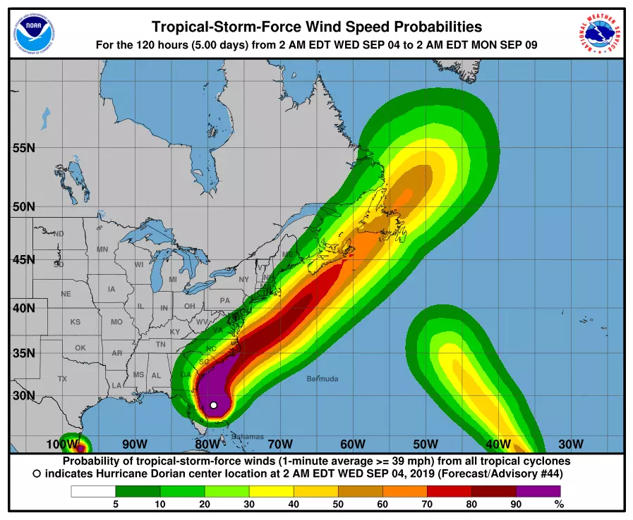
Over the next 24 hours, Hurricane Dorian will slowly track along the east coast of Florida, Georgia, and the Carolinas. As of 5 a.m. Wednesday, the center of Dorian is about 100 miles due east of Daytona Beach, Florida. (That is about 725 miles south of Cape May, New Jersey.) Winds have come down slightly overnight, sustained at 105 mph. The storm is moving toward the north-northwest at 8 mph.
On Thursday, Dorian will probably make landfall along the North Carolina coast. At the same time, here in New Jersey, we'll start to see and feel Dorian's far northern edge in the form of mostly cloudy to overcast skies. A few showers may bubble up from the south starting Thursday afternoon. Meanwhile, we'll lose the "t-shirt and shorts weather" with unseasonably cool high temperatures in the lower to mid 70s.
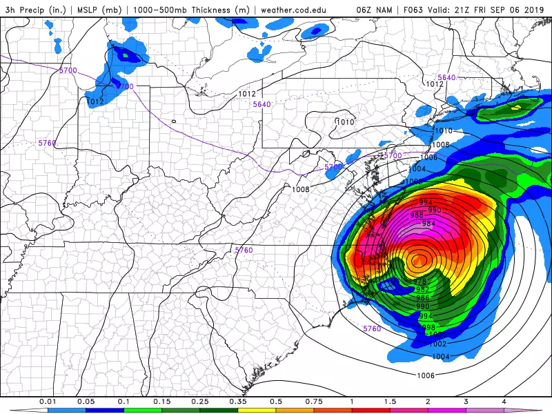
Friday is going to be the "yucky" day of the week, as Dorian makes its closest pass to New Jersey — about 300 miles from Cape May to Dorian's center. In general, for most of New Jersey, it is just going to be a breezy, showery, cloudy, cool day. (High temps will struggle to reach 70 degrees.) Nothing remotely close to hurricane conditions.
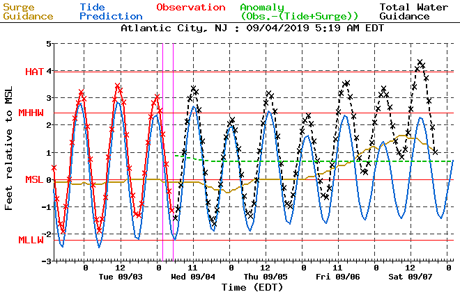
However, along the Jersey Shore, Dorian's impacts will be a bit more significant. Northeasterly winds may gust to 40 mph right along the coast. Barely tropical storm force, but that's strong enough to cause power outages and minor property damage. That wind will surge ocean water toward our coastline, raising concerns for rough surf (4 to 6 foot waves) and coastal flooding (1 to 3 feet of surge). Seawater inundation and flooding-related road closures will be possible during the Friday morning (2 a.m.), Friday afternoon (2 p.m.), and Saturday morning (3 a.m.) high tide cycles.
The bottom line... The farther south and east you are, the more likely you'll be to feel the outer edge of Hurricane Dorian. I am most concerned about the coastal flooding potential. Followed closely by those 40 mph winds. Tropical rainfall is not expected here in New Jersey.
By the time you wake up Saturday morning, Dorian will be out of our hair. In fact, the weekend looks quiet and pleasant. Sunny and a bit breezy on Saturday, with highs in the upper 70s. Partly sunny and near 80 on Sunday.
By the way, Dorian is not alone in the Atlantic basin:
1.) Tropical Storm Fernand will make landfall north of Tampico, Mexico on Wednesday.
2.) Tropical Storm Gabrielle is way out in the eastern Atlantic Ocean, a full 2,800 miles away from New Jersey. The current forecast track pulls Gabrielle out to sea (east of Bermuda) by early next week.
3.) A tropical wave near Bermuda may develop into a tropical cyclone (50% chance).
4.) Another tropical wave coming off the west coast of Africa will be the next storm to watch closely.
It's not surprising at all that the ocean is heating up. The climatological peak of the Atlantic hurricane season is September 10.
More From Lite 96.9 WFPG


