

Frigid forecast rolls on – midweek snow still a close call for NJ
A coastal storm system skirting past the Jersey Shore on Thursday will potentially add a chance for snow to this unseasonably cold forecast.
First of all, it's cold. (Obviously.) And it will continue to be frigid (well-below-normal, mostly below-freezing) for the next 6 days. I'm still eyeing Monday 1/8 as the start of a (temporary) warmup. Highs on Tuesday will be limited to the mid 20s, with a wind chill stuck in the teens at best through the afternoon.
Second, we're still watching a winter storm that looks to impact New Jersey in the late Wednesday night-Thursday morning time frame. Since Monday afternoon's forecast update, model consensus has drifted east slightly. (That's the out-to-sea direction.)
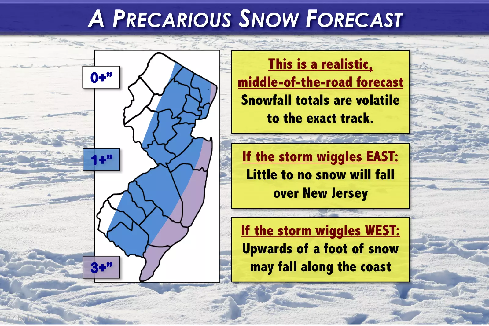
This is still a highly precarious and extremely volatile forecast. If the storm wiggles to the east, we'll hardly see any snow. If the storm wiggles to the west, we'll get buried.
My first-stab snowfall map is a conservative, middle-of-the-road, realistic forecast, based on the latest data available. Although forecast confidence remains shaky, I feel comfortable communicating these numbers publicly — I believe there is an equal chance of needing to increase, decrease, and hold steady as the storm gets closer.
It is worth noting that the shorter-range, mesoscale models (namely the 06Z NAM) are starting to point toward a more significant snow event. Trend or fluke? Too early to tell — one run does not a forecast make. If models continue to trend in this direction, we'll ramp up our snowfall forecast accordingly. Honestly, it is within the realm of possibility that we'll need to double or triple this initial snow forecast in a perfect storm setup.
A few additional notes:
1.) No matter where the storm track ends up, New Jersey's coastal counties (Monmouth, Ocean, Atlantic, and Cape May) will see the biggest snowfall accumulations.
2.) The storm timeline hasn't changed: First flakes around Midnight Thursday morning, ramping up mid-morning Thursday, tapering off by Thursday late afternoon.
3.) The range of potential snowfall totals that I have seen for this storm literally runs from 0 to 12 inches.
4.) Coastal flooding and beach erosion are still concerns, but I'm uncertain as to the magnitude and timing. It all depends on the track and the wind direction.
Hopefully I've made the case that you need to monitor this snowfall forecast carefully, whether you live in the "sweet spot" along the coast or not. We'll keep you posted with twice-daily weather blog posts and regular on-air forecast updates as the storm approaches.
Perhaps even more important than the snow will be the ensuing wind and cold. High temperatures on Wednesday and Thursday will be near 30 degrees — in fact, thermometers may briefly pop above freezing in South Jersey on either day. However, as a northwest wind gusts to 40+ mph behind Thursday's coastal storm, temperatures will nosedive once again.
Friday's high temperature forecast ranges from 13 to 20 degrees. With a continuing gusty wind to 40+ mph, the wind chill will stay below zero all day. That is ridiculously cold. Dangerously cold. No joke, there may be some school delays and even closings due to this extreme cold.
Saturday looks to be the coldest day yet, with morning lows at or below zero and highs only between 12 and 18 degrees. Once again, wind chills will not break 0 all day long.
On Sunday, thermometers should recover to the still-below-freezing mid-to-upper 20s. Monday's high temperatures are predicted to push into the upper 30s to lower 40s — rejoice! (But watch out for a few showers early next week too.)
More From Lite 96.9 WFPG


