

Coastal storm aims for NJ Friday night-Saturday: 9 things to know
Here is the latest rundown of this weekend's wind, rain, and tidal flooding threat for New Jersey.
1.) Short-Term Forecast
Before I dive into the nastiness, let's talk about the quiet, cool weather that will continue for Thursday. A mostly sunny morning with lows in the 30s. Increasing clouds through the afternoon with highs in the 50s. (That's about 10 degrees below normal for late October.) Winds will be lighter than Wednesday, and we will stay dry all day. Not a terrible weather forecast, but you will need a jacket or sweater all day.
Skies will become mostly cloudy by Thursday night. Frost is possible, as lows dip into the mid to upper 30s overnight.
And then most of Friday will be cloudy, with high temps in the mid 50s. A shower or sprinkle will be possible at any time. That's before our weather goes steadily downhill with widespread rain and wind arriving late-day.
2.) Forecast Play-by-Play
My morning perusal of the latest model guidance has yielded two changes to our coastal storm forecast: it has slid 1.) slightly earlier and 2.) slightly east. That means the nastiest weather is now firmly expected to occur while you're sleeping late Friday night to early Saturday morning. That also means we should salvage part of the weekend, with drier (and maybe sunnier?) weather resuming late Saturday into Sunday. Finally, this update includes a scaled-back coastal flooding forecast, as a subtle shift in wind direction will push less ocean water up against the Jersey Shore.
3.) Yes, It Is a Nor'easter
The science of meteorology is full of very specific terminology. In communicating the forecast effectively, I have to maintain a balance of 1.) accuracy, 2.) precision, and 3.) non-hyperbole.
Keeping that in mind, yes this is will be a nor'easter. It is literally the name of this phenomenon, named for the northeasterly winds that accompany this particular storm track. The definition has nothing to do with the strength of the storm or snow (necessarily).
To those accusing me of hype and inciting panic by using this term, just stop. Especially since I've generally favored the term coastal storm anyway.
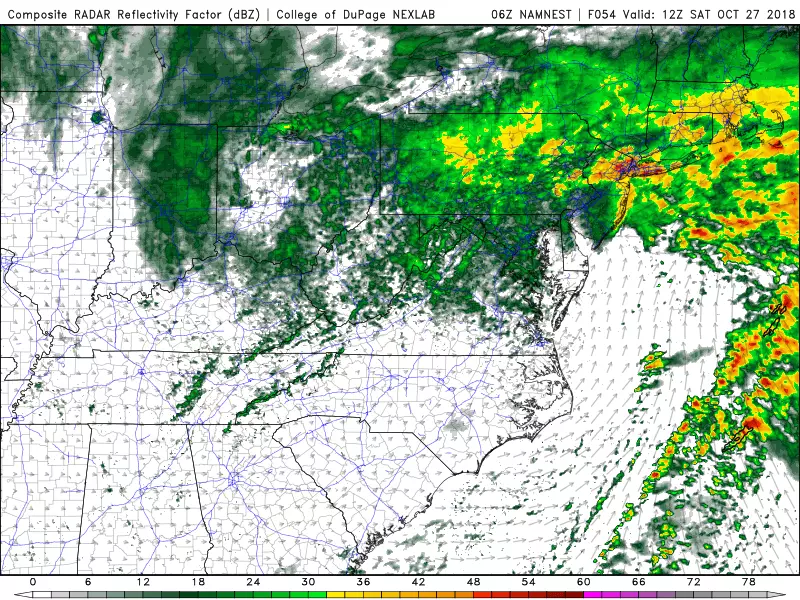
4.) Latest Timeline
--Late Friday Afternoon (4 p.m.)... Widespread light to moderate rain pushes into southwestern New Jersey (at the earliest).
--Friday Evening (8 p.m.)... Steady rain spreads northward through the rest of the state.
--Early Saturday Morning (2 a.m.)... Prime time, with the heaviest rain and strongest wind gusts. Good luck sleeping through it.
--Saturday Mid-Morning (10 a.m.)... Wind-driven rain slowly subsides through the rest of the morning, from southwest to northeast.
--Saturday Midday (1 p.m.)... Tapering to breezy showers, becoming more scattered through the afternoon and evening hours. Even though the afternoon will be significantly drier than the morning, it will remain cloudy and generally yucky.
--Saturday Night (10 p.m.)... Widespread rain threat comes to an end in New Jersey (at the latest).
5.) Heavy Rain
As noted in the timeline above, periods of moderate to heavy rain are expected from late Friday night through early Saturday morning. Widespread rainfall totals between 1 and 2 inches are expected across New Jersey, with locally higher amounts in case of heavy downpours and/or training storms. (Where rain cells form and re-form over the same area repeatedly.)
The deluge of rain may lead to flooding of streets and/or waterways. Especially in NW NJ where flash flood guidance shows just 2 inches of rain within 6 hours could cause rising water. Visibility may be an issue as well, especially with the heaviest rain occurring during the dark overnight hours.
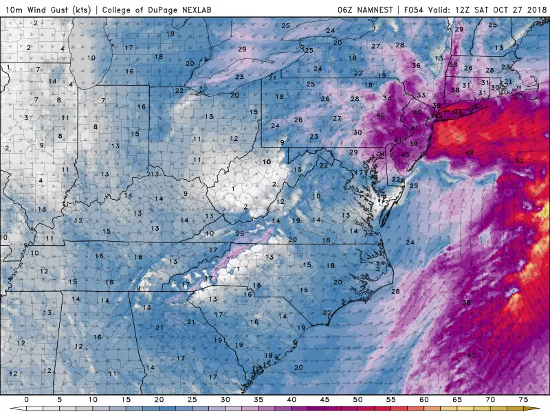
6.) Howling Wind
My latest guesstimate shows sustained northeasterly winds of 20 to 30 mph early Saturday morning, with gusts to 45 mph. As we have discussed, that's fierce enough to cause scattered power outages, make driving difficult, and blow around garbage cans and Halloween decorations.
7.) Minor-Moderate Coastal Flooding
On Wednesday, the tide guidance looked pretty ominous. With winds driving straight out of the east for most of the storm's duration, upwards of 3 feet of surge would cause widespread "moderate" flooding.
Now that the storm has shifted a few miles eastward, that puts New Jersey under the influence of mainly northeasterly winds. A subtle change that has reduced the oceanfront surge estimate to the 1 to 2 foot range. That equates to tidal flooding in the "minor to moderate" range. (I think the earlier timing of the storm's brunt helps too.) Good news, but still a precarious situation that we'll have to continue monitoring carefully.
The "usual spots" will probably see periods of water inundation. But hopefully the track shift will be just enough to avoid the sustained flooding, impassable major roads, and property damage.
8.) Snow? No!
I never fully bought into the threat for cold temperatures and wintry weather from this storm. And I'm now even more confident in saying it's not going to snow in New Jersey this weekend.
The coastal storm system itself will carry humid, warm air with it. As NJ's southern coast taps into that tropical air, temperatures may spike into the mild lower 60s on Saturday. Even North Jersey will be no cooler than mid 40s for the duration. That is just not cold enough to sustain snow, sleet, freezing rain, ice, or frost.
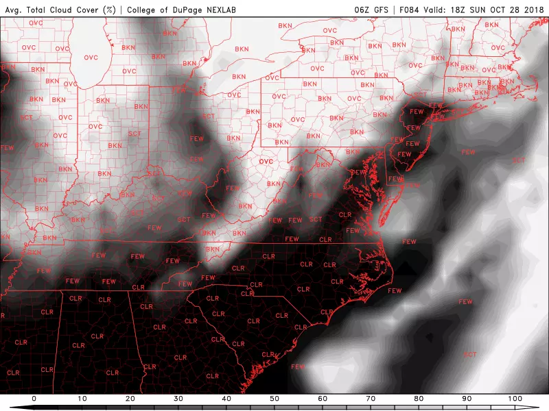
9.) Salvaging Sunday
As I mentioned, the earliest storm timeline means we'll probably salvage the second half of the weekend! Actually, the forecast for Sunday has improved quite a bit, making it the clear shining star of the weekend.
Yes, it will remain breezy. And I can't rule out an isolated shower. But models are favoring a mostly dry forecast, with breaks of sun emerging by Sunday afternoon. And the coastal storm's more eastward trajectory will limit the amount of cold air that gets dragged down from the north on the backside. That means we might hit 60 degrees on Sunday — not bad!
Next weather blog update expected by 7 a.m. Friday.
More From Lite 96.9 WFPG


