

Tuesday temperatures 20 degrees above normal for NJ
New Jersey's warming trend will kick up another notch on Tuesday, with widespread 70-degree temperatures in the forecast.
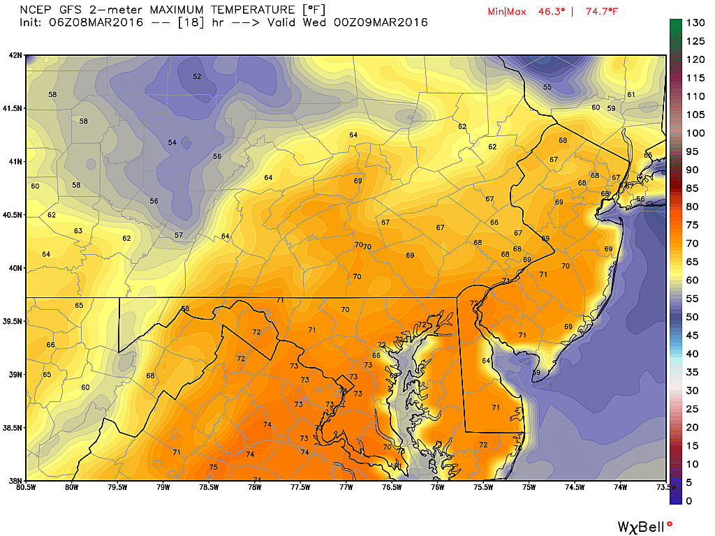
Unseasonable warmth is the theme of this week! A runaway train of rising temperatures will peak Wednesday and Thursday at near-record levels.
Tuesday morning's temperatures bottomed out mostly in the 40s, with a few pockets of 30s in the traditionally coolest spots. A light jacket will be necessary as you walk out the front door, but at least you won't be hit in the face with bitter cold air.
You won't need that jacket by Tuesday afternoon, as partly to mostly sunny skies and warm air fuel a warmup to around 70 degrees. That is about 10 degrees warmer than Monday and about 20 degrees above normal for early March. Record highs are in the upper 70s today, and should remain safe.
Additionally, there are a few light rain showers showing up on radar. So don't be surprised if you see a sprinkle sometime on Tuesday. However, you can safely leave the umbrella at home.
Thanks to warm air, a bit of humidity in the air, and a few clouds, Tuesday night's low temperatures will only be able to fall into the upper 40s to lower 50s across most of the state. Again, this is about 20 degrees above normal for this time of year.
New Jersey's warm streak will peak starting on Wednesday, as statewide high temperatures climb to the lower to mid 70s. The warmest number in my forecast is an impressive 77 degrees for part of South Jersey on Wednesday. A stiff breeze, sustained to 20 mph with gusts to 30 mph, will keep the warm air moving.
Thursday will be the second potentially record-breaking day of the week, with high temperatures again in the lower to mid 70s. I could see a few afternoon temperatures in the upper 70s in South Jersey on Thursday. The GFS model even suggested a reading of 81 degrees! But that's the first 80+ suggestion I've seen this week, so I'm hesitant to go that warm quite yet.
The forecast gets complicated late Thursday into Friday, as a front slowly sags into New Jersey. While this front looks mostly dry, I have injected some thick clouds and a chance for a shower into Friday's forecast. Again, the front's forward progress is expected to be very slow, and may even stop (stall) for a period on Friday in the neighborhood of North Jersey. Given this solution, I believe at least the southern half of the state will remain in the warm sector (70+ degrees) for most of Friday. Even near the front in North Jersey, highs should remain well above normal in the 60s.
By Saturday, however, the front will complete it's push through New Jersey, and so we'll see a cooldown and a few showers. Models currently paint Saturday's high temperatures in the lower to mid 50s. Yes, that's 20+ degrees cooler than our peak warmth on Wednesday and Thursday. But it's still above normal for early March!
As an area of low-pressure rides into the Garden State on Sunday, there's a chance for an extended period of steadier rain. I don't want to call Sunday a "washout" just yet, but a pretty wet day is a good possibility. We'll have a better idea of timing and impacts later this week.
Through the rest of the month, we'll probably alternate between a few days of "warm" and a few days of "cool". (Typical March weather.) While a big snowstorm is becoming increasingly unlikely in New Jersey, we could still see a few snowflakes if it gets cold enough.
More From Lite 96.9 WFPG


