

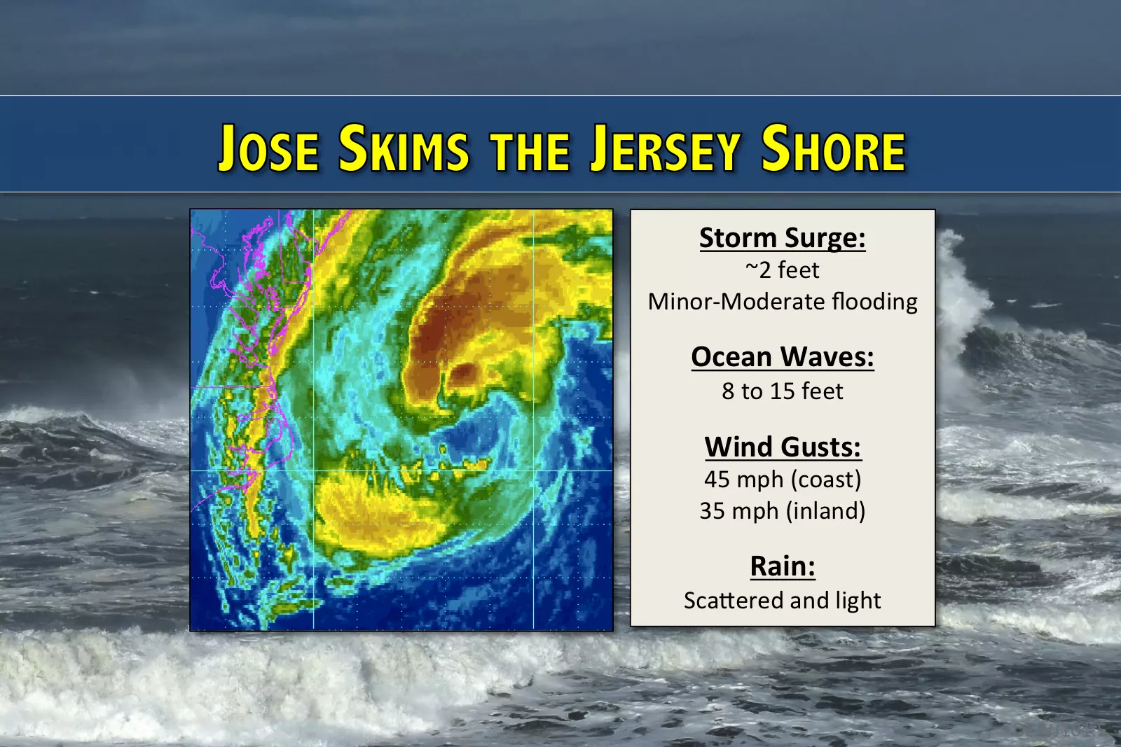
Jose’s impacts on NJ: big surf, gusty winds, and a bit of rain
As the center of Hurricane Jose stays about 250 miles off-shore, the storm's biggest impacts will be felt along the Jersey Shore.
As of this writing, we've already seen some big waves and wind gusts over 30 mph along the Jersey Shore. Everyone in the state will get at least a little taste of Jose on Tuesday. And we'll be holding our collective breath during high tide, due to a moderate threat of coastal flooding. However, as I've been stressing for a couple days now, true tropical storm or hurricane conditions will stay well to our east.
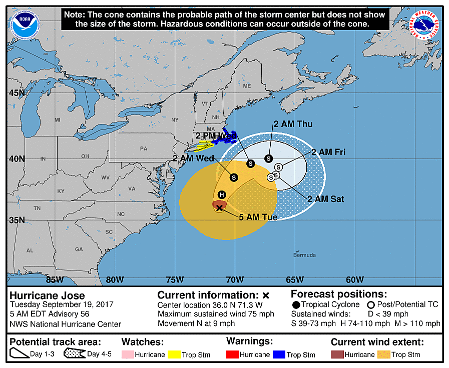
As of 5 a.m. Tuesday morning, Jose is still a minimal hurricane, with maximum sustained winds of 75 mph. It should pass about 250 miles of the Jersey Shore on Tuesday, before turning eastward, further out-to-sea
The nowcast for New Jersey differs very little from our previous forecasts. The question marks surrounding heavy rain bands have been resolved — it's not going to happen. I also dropped potential wind speeds slightly (on the order of 5 to 10 mph) given the Jose's present size and strength.
Here's a rundown of what to expect Tuesday:
--Scattered rain is expected throughout the day, but should remain light and won't amount to much. Rainfall totals will amount to a few tenths of an inch, at the most.
--Wind gusts to 45 mph are possible along the coast, and 35 mph for inland New Jersey. Call it "breezy" to "gusty".
--Storm surge of 2 feet will cause minor to moderate flooding along tidal waterways at high tide.
--Ocean waves between 8 and 15 feet with make swimming extremely hazardous, and will probably cause significant beach erosion too.
As I've said previously, Tuesday reads as a "yucky" weather day. We'll be watching the coast carefully on Tuesday, as minor to moderate water inundation issues may necessitate road closures. High tide will occur along the Atlantic Ocean between 6:30 a.m. and 8:00 a.m. and again from 7 p.m. to 8 p.m. Rememeber, high tide along back bays and tributaries occurs 2 to 3 hours after high tide along the oceanfront.
The coastal flooding threat should fade substantially after four higher-than-normal high tide cycles: Tuesday morning, Tuesday evening, Wednesday morning, and Wednesday evening. There is some evidence that minor cateogry tidal flooding will be possible along the northern NJ coast (i.e. Monmouth County) on Thursday too.
As Jose pushes farther out to sea Tuesday night, shower chances will fade and the brisk wind will subside. However, as the storm stalls just off the coast of Cape Cod, Massachusetts, our surf will remain rough for several days to come — potentially through early next week.
I previously mentioned the possibility of Jose "slingshotting" back toward the East Coast by the weekend, a solution that came up in one rogue run of the Euro model a few days ago. I'm confident this solution will not occur. Beyond Wednesday morning, New Jersey should be done with weather impacts (rain and wind) from Jose.
Beyond Jose
After the storm departs, temperatures will start to cook. As sunshine returns on Wednesday, high temperatures should bump into the 80s across most of New Jersey. It will still be humid, and it will still be a bit breezy.
Thursday looks like a summery day too, with widespread 80s, high humidity, and mostly sunny skies.
Autumn official begins on Friday at 4:02 p.m. and we'll welcome the new season with significantly lower humidity! (Yay!) With a few clouds overhead, temps on Friday will be slightly cooler than the previous couple of days. We'll probably still top 80s degrees for a good portion of the Garden State.
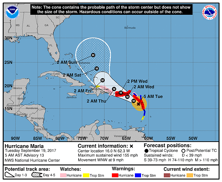
Hurricane Maria
Maria crossed the tiny island nation of Domenica Monday evening as an incredibly powerful Category 5 hurricane, and is now barreling through the Caribbean Sea. It's the Atlantic basin's 2nd category five storm and 4th major hurricane not just this season, but in the past month! Our hyper-active hurricane season continues.
Will Maria impact the U.S. East Coast? Way too early to tell — there are still many directions the storm may turn as it exits the Caribbean. Even if it does aim up the coast (admittedly the most likely solution at the moment), it would be in our neighborhood for another 7 to 10 days. So for now, we sit and watch. I expect we'll have more clarity by the end of the week (Friday or Saturday) — not before.
More From Lite 96.9 WFPG


