

A pair of winter storms aiming for NJ: Snow, rain, ice, and wind possible
Quiet for Now
I'll keep the short-term forecast brief, so we can fully discuss the complicated double-dose of yuck coming later this week.
Tuesday morning is starting off very cold and frosty, with temperatures mostly in the teens. In SW NJ, where there's still some snow on the ground, there have been some single digit temperatures. It's going to be a seasonable, par-for-the-course January day with high temperatures around 40 degrees. Skies will progress from morning sunshine to afternoon clouds.
Tuesday night will be dry and cold once again. Lows are forecast to dip into the lower to mid 20s, under partly cloudy to mostly clear skies.
Wednesday also looks quiet, with a mix of sun and clouds. High temperatures in the lower 40s will be a hair above-normal for this time of year. An approaching front appears very moisture-starved, but it could fire off an isolated late-day snow shower. (Admittedly, the more I look at it, the more I'm thinking we'll just see some flurries flying around. If that.)
Cooler air returns on Thursday, with highs back down to the mid 30s. Increasing clouds will lead to our next substantial storm system, which should not impact New Jersey until Thursday evening at the earliest.
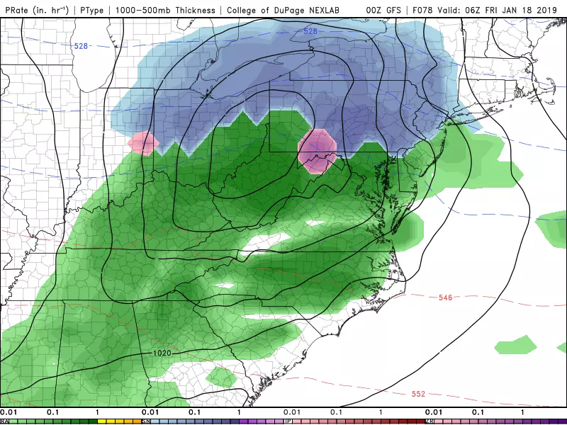
Storm #1: Thursday evening — Friday
--Bottom Line: A weak storm system will produce snow Thursday night, changing over to rain by Friday. There could be a few slushy inches of accumulation to the northwest, and Friday morning's commute could be messy (whether wintry and/or wet).
--Timeline: First snowflakes arrive Thursday evening as early as 7 p.m., with light to moderate snow overnight. As temperatures rise, a transition from snow to wintry mix to rain will occur from south to north. By 5 a.m. Friday morning, precipitation should have turned to all rain in southern and coastal New Jersey (at least). By 11 a.m. Friday, it should be all rain. Precipitation should taper off by 5 p.m. Friday, at the latest.
--Totals: Before the transition to rain, some snow accumulation is possible. Higher snow totals will be found north and west of the NJ Turnpike, on the order of 1 to 3 inches (slushy). A coating to an inch is possible just southeast of the Turnpike. Little to no accumulation is anticipated in our coastal and southern counties. (If this forecast holds, I'll publish a snow forecast map on Wednesday morning.)
--Confidence: Moderate: storm will happen, will impact New Jersey, and will have a complicated transition from snow to rain. Low: timing of the transition, snowfall totals.
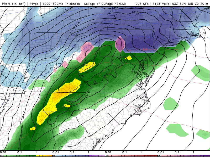
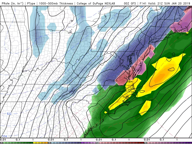
Storm #2: Saturday evening — Monday morning
--Bottom Line: The stronger, more complicated of our two impending storm systems. It could be a pretty nasty storm, with heavy snow possible to the northwest and heavy rain and/or heavy icing to the southeast. As the onset of this storm is still over 100 hours away, there are still way more question marks than definitive answers.
--Timeline: First snowflakes look to arrive in the Garden State around Saturday evening. As temperatures rise into the 40s overnight for most of the state, most precipitation will rapidly flip over to rain. (Far North Jersey (around Sussex County), we may or may not see a transition from wintry to wet.) Starting sometime late Sunday morning, colder air will return, enacting a transition in the other direction from rain to wintry mix to snow. Precipitation does not look to end completely in New Jersey until early Monday morning. So there could be significant travel issues for the Monday morning commute — although it will be lighter than usual due to the MLK Day holiday.
--Snow Totals: Highly dependent on the track of heaviest precipitation and the timing of the snow-rain-snow transition. For northwestern New Jersey, double-digit snow totals (up to about 14 inches) are possible, but it's far from a guarantee. (One model shows only 2" for NW NJ.) Along the coast, it's just as complicated, although less impactful — potential snow totals range from next-to-nothing to upwards of 4 inches.
--Ice Totals: The transitions from snow-to-rain and rain-to-snow are precarious — in between raindrops and snowflakes, there could be an extended period of sleet and freezing rain. Such ice storm conditions can lead to a dramatic decrease in traction. Even with only a light glaze of ice accretion, roads could go from dry to dangerous in a matter of minutes. Heavier icing would raise the risk of downed trees and power lines.
--Rain Totals: It is totally possible that NW NJ gets buried by snow, while SE NJ has to endure heavy rain and flooding. If any corner of the state experiences mostly or all rain from this system, 1 to 2 inches of total rainfall is a good possibility.
--Wind: It will get breezy during this storm, as the cooldown kicks in Sunday. Northerly winds of 10 to 20 mph are expected, with possible gusts to about 40 mph. Not only will that be blustery, it may lead to blowing snow and further reduced visibility.
--Coastal Flooding: The latest model run shows less of a fierce on-shore wind direction than previously anticipated. Still, a brisk southeast/northeast wind combined with an almost-full moon could lead to some flooding along the Jersey Shore. Tidal guidance is only reliable out to about 72 hours, so I don't have specific surge numbers or flood categories to share just yet.
--Confidence: Low to very low. The storm track and timing are still very much in question, which will directly impact who sees snow/ice/rain and when. We will start to piece together finer details starting Thursday morning, but not before. And as I've mentioned, given how sensitive this forecast will be to the exact track and exact temperatures, we may not have a full handle on this storm until it arrives.
Quite a headache of a forecast this week! We'll keep you posted as things continue to evolve. Next weather blog post expected by 7 a.m. Wednesday.
More From Lite 96.9 WFPG


